|
INDUS VALLEY CITY of
|
In the early 1920s, an Indian archeologistüfs curiosity lead the Bronze Age city of Mohenjo-daro, which had long been buried under a hillock, to be discovered. It was the largest city of the Indus Valley Civilization, also called the Harappan Culture, and was based on regular city -planning. After the discovery of Mohenjo-Daro, the history of India was obliged to be rewritten, since it became clear that Indus Valley Civilization, represented by these two cities of Harappa and Mohenjo-daro, could be traced back to the age before the advent of Aryan people coming to India. The credibility of the hypothesis that Aryans destroyed this civilization still cannot be discarded. |
|
R.D. Banerji (1885-1930), Indian archeologist, used to wonder full of curiosity, what was buried under that hill, when he recalled a hillock soaring near the Indus River in Sindh province, now southern Pakistan. The first excavation started in 1922, and a little digging instantly found the remains of walls, the considerable scale of which made Indian archeological society very excited.
What was discovered by Banerji was soon ascertained to be a representative site of the Indus Valley Civilization, which along with Harappa was presumed to have begun 4,500 years before. It was referred to as Monhenjo-daro, meaning the üemound of the deadüf.
There was not a more impressive site than Mohenjo-daro among the excavations executed in the basin of the Indus River in the 20th century. When it was discovered, the remains were kept in a well preserved state and this revelation made previous theories on Indian history mistakes, for the commencement of the ancient civilization in India, including its literature, art, and architecture, was believed to have been after the advent of the Aryan people, who had come south from Central Asia.
Although Mohenjo-daro was saved from oblivion by Banergi, it still waits the elucidation of numerous mysteries about Indus Valley Civilization. Thanks to the age determination by radioactive-isotope-14, it came to be possible in the 1950s to know the living period of organisms in various fields. However, every trial to decipher Indus script, which was expected to be able to make clear the religion, politics and society in the ancient eras, collapsed entirely before completion.
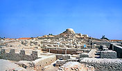
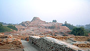
Like other excavated cities of this civilization, Mohenjo-daro was composed of urban districts in the east and a citadel in the west. The former was older, spreading over extensive area under a hill, making its streets in regular grid patterns, with the three wider of north to south and two of east to west, intersecting at right angles.
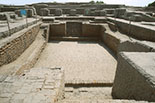
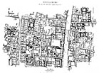  Plan of the HR. Area and a small lane in the area What deserves special mention is that sewage was disposed of by a well-maintained system, which was networked between building, and there were overflows at regular intervals to prevent clogging with rubbish. The social structure must have been complex, for there coexisted hundreds of houses of various types of houses. In housing areas, most of them were guarded with thick walls of two-story height. Their walls facing a large street have no openings, so entrances were usually at the sides of small lanes. Every house mostly had a private well and was supposed to let their windows facing its courtyard have a lattice of alabaster or clay. From those eras on, the flooding of the Indus River has been dreaded. The lower town districts provided platforms with piled bricks to erect houses on them using burnt bricks. Even then, flood water, from the river that could swell up to 16 times larger than usual, could inundate areas near the river. That can be presumed from all buildings along the so-called üeFirst Main Streetüf which remain almost intact.
The citadel on the western artificial hill, which occupies eight hectares, embraced many public buildings of Mohenjo-daro, but one cannot find remains of any grandiose palaces, mausoleums, or temples. There might not have been powerful royal authorities there, but peopleüfs welfare was always prioritized. That is the most important characteristic of the Indus River Civilization.
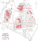
 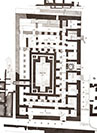 Map of Citadel and plan of the Great Bath
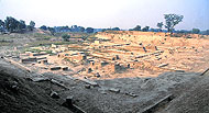
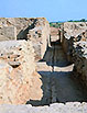
There is a large pool, generally called the üeGreat Bathüf in the citadel, which is 7 by 12 meters in scale and surrounded by five rectangular terraces. At the center of the northern and southern sides of the Great Bath are flights of stairs with five steps to descend to the bath. The walls of the place were made of burnt bricks, elaborately stuck without gaps, and their backsides were covered with water-proof tar three centimeters thick. Furthermore, there was drainage under it, which was connected to the cityüfs sewerage.
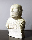
At the west of the Great Bath are 27 brick podiums, on each of which was a large rectangular edifice. They are presumed without doubt to have been granaries. There were devices of ventilation to avoid the decay of amassed grain. As for the weather of 4,000 years ago in the basin of the Indus River, the temperature was lower than now, and it rained more, which seems to have allowed more flourishing agriculture. Although archeologists expected a great progress in elucidation of the Indus River Civilization thanks to the unearthed objects from the citadel, it proved to be a flash in the pan. The most important discovery was a bust of a high rank person, made of steatite, wearing a narrow headband on his forehead and a mantle over his shoulder. Since it resembles a statue of a king from Mesopotamia and his mantle has a trefoil pattern, a sacred symbol, this statue was designated as üeKing Priestüf.
The area of the Indus River Civilization was broad, spreading from the foot of the Himalayan Mountains in the north to the Gulf of Cambay in the south, and from the Makran Region in the west to the current Delhi environs in the east, pushing the development of urban culture in the Indian Subcontinent.
On the other hand, John Marshall, a British archeologist, admired the unearthed jewels, saying ügthey were so excellently processed and polished that they could be said to have been just brought from a jewelry store in London.üh The reason for the downfall of the city of Mohenjo-daro has not yet been elucidated. While there are traces of a heavy flood, the demolition by Arians, who invaded India around the 15th century B.C.E., can also be considered. The exhumations of human bones in unnatural postures and scarred skulls, as well as excavations of axes, arrows and spears, which did not belong to the Indus Civilization, might have been evidence of wholesale slaughter. Mohenjo-daro is the most in danger of collapsing among the UNESCO World Heritage Sites in Pakistan. In its citadel soon after the excavation, affected by the air and rain, the salinity adhered on the walls began to crystallize, and the bricks began to crumble. And as the irrigation system brought from the Indus River in 1932 raised the groundwater level in this area, deeper excavation has not been possible since then.
Although damaged bricks were replaced with new ones, it was considered in the early 1960s that the ruins would inevitably collapse. Accordingly, based on the appeal of Pakistan, UNESCO called to many countries for aid to the ruins. The contributions made possible the establishment of facilities to lower the level of groundwater, and prohibition areas of agriculture were decided. However, the crisis of collapse has still not disappear.
The notion of ügAriansüh mainly indicates a portion of the Indo-European language speaking people, who settled in India and Iran. The region they originally inhabited is not exactly clear. The hymns of the oldest Indian literature by them, the ügVedasüh, called themselves üeAriansüf, meaning the üeexaltedüf. The Vedas depicted the main god Indra as the victor against his demon-enemies, Dasas. This means that the Arians conquered the original inhabitants with dark skin and enslaved them.
The Arians invaded the current Punjab region in about 1,500 B.C.E., and gradually advanced to the middle area of the Ganges River Valley, mixing with Indian aborigines and settling there. One theory tells that they destroyed the Indus Valley Civilization and the aborigines that escaped to southern India became current Dravidian people. Though there is no corroboration for this, it cannot be completely denied either. The nomenclature üeAriaüf itself is a source of perplexity, for primeval nations usually called themselves üepeopleüf or üeweüf but calling themselves the üeexaltedüf was quite exceptional. The word üeAriaüf is mainly used for languages at present. The Indo-Arian languages belong to the Indo-Iranian languages, or a linguistic family of the Indo-European languages, including Hindi, Urdu, Bengali, Pali, Sinhalese, and so on in the Indian Subcontinent.
(In "UNESCO World Heritage" vol. 5. 1997, Kodan-sha ) |
E-mail to: kamiya@t.email.ne.jp