|
ANCIENT GANDHARAN CITY of
|

|
ANCIENT GANDHARAN CITY of
|
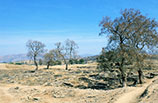
Along the highway between Rawalpindi and Peshawar are located the ruins of Taxila, a once thriving trading city in ancient times. It must be one of the most important archaeological sites in Asia, though many of the ancient urban facilities in its vast area have yet to be excavated. Not only was its city planning influenced by Greece but there are also Buddhist temples or stupas in the mixed style of Greek and Indian architectures, and furthermore even Islamic mosques and madrasas were built later. These remains indicate the cityÅfs long cultural development from the 6th century B.C.E. to the early middle ages. |
|
It is said that Taxila was a village as early as in the Middle Stone Age. The reason it became one of the most flourishing trade centers in ancient times was its geographic advantage in its location along one of the Silk Routes, or caravan routes, connecting China and West Asia. An Indian myth tells that the name Taxila derived from the prince named Taksha, who had ascended the throne here. Therefore, it was referred to as Takshashila in Sanskrit, while common people also called it Takhasila from long ago, literally meaning the town of Takha tribe. Taxila was a commercial city that saw recurrent rise and fall, while it was also a cultural city of the Persian Empire of the Achaemenid dynasty from the 6th to the 4th centuries B.C.E. It was in the 4th century B.C.E. that Alexander the Great (r. 336 -323 B.C.E.) invaded the city, bringing Hellenistic culture to the Gandharan area. In the 3rd century B.C.E. the city was ruled by the Mauryas and its king Ashoka (r. 336-323 B.C.E.) is said to have established here a Buddhist University. In around 180 B.C.E. Greeks came and settled in the Sirkap district, constructing a new city, then in the 1st century the Kushan dynasty built the third city in Sirsukh district and kept it as the EmpireÅfs capital till the 3rd century.
The invasion of the Huns in the 5th century triggered TaxilaÅfs decline, and incessant conflicts between nobles lead the city into collapse. Much later, when Muslims intruded into this mountainous city under the flag of the prophet Muhammad, the former habitants left the city. The current main urban remains are in three districts: Bhir Mound, Sirkap, and Sirsukh; in addition, many other temples, monasteries, and stupas are scattered among nearby mountains.
The Bhir Mound is considered to have been the oldest settlement in Taxila, the foundation of which goes back to the 6th century B.C.E. under the rule of the Achaemenids. We can even find there a sign of intended urban development. In the eastern excavated area, there is a housing district around a square. Its houses were erected on stone basements and the posts sustaining roofs were wood, but houses at the crossroads had stone columns on their corners in order to avoid damage from the crashing of carts. Moreover, it was designed that sewage flowed into public or private Åedrainage wellsÅf to eventually percolate down through the earth. Among excavated areas, a semi-circular region at the cross point of the second and third streets in the west is conspicuous, appearing to have been the administration center of the city. The remnants of its group of buildings include an edifice with three pillars inside, called the Åeassembly hallÅf. It remains controversial whether it was for funeral use or not.
Terracotta figurines unearthed at the Bhir Mound often depict couples of male and female deities hand in hand like Mithunas, but a theory that there was actually here a Hindu temple, the earliest in the Indian Subcontinent insisted on by some Pakistani people, has not yet been proved.
 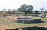 The main street and apsidal temple in Sirkap
The Sirkap region was constructed in about 180 B.C.E. by Greeks, who had come in crossing the Hindu Kush mountains from the Bactrian kingdom in current northern Afghanistan. The city was arranged in an orderly grid system after the first century B.C.E., with a grand main street penetrating the city from north to south.
Before the city of Sirkap would be destroyed by the Kushan Empire in the first century, many religious buildings were erected along the main street. The largest was the apsidal temple laid out in the center of a vast precincts surrounded by roadside buildings on one side and thick walls on the other three.
  Small stupa in Sirkap Near this temple is the Åeshrine of double-headed eagleÅf surmounted with a small stupa. The walls of its stereobate are partitioned with pilasters with Corinthian capitals, which was probably brought by the Kushans, and each division has a relief; Greek-style gabled temple, a Chaityagriha like those seen in the Ajanta caves, and a Torana gate like in Sanchi, respectively. The gable of the relief temple is likely to have been decorated with painted animal figures.
In this shrine coexist various styles from various regions in the world, indicating that this was a knotting place of the arts of East and West. There is a legend that St. Thomas, one of the twelve apostles, stayed here at a palace in 40 C.E. on the way south to India on a missionary journey, and he had an audience there with the Indo-Parthian king, Gondopharnes.

The remains of the city of Sirsukh, constructed by Kushanas, also plainly indicates Greek influence. Although it adapted itself to the natural configuration like hills and streams, the whole city was encircled with high walls, with hemicycle bastions, in a rectangular plan, similar to other Central Asian cities.
  Great Stupa of Dharmarajika
When the Huns invaded and pillaged Taxila in the 5th century, not only the city of Sirsukh but also the Buddhist temple of Dharmarajika were demolished. This temple had the greatest stupa in Pakistan called Chir Tope by local people. Its central core was erected in the 4th or 5th century.
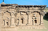
  The monastery of Jaulian and its sculpture To the east of Sirsukh is the temple of Jaulian. Many small reliefs of Buddha in the meditation pose, on the surviving grand StupaÅfs walls partitioned with pilasters, allow us to imagine the splendidness of destroyed buildings in bygone days. To the west of the temple of Jaulian is the temple of Mohra Moradu, where the Stupa and Vihara (monastery) are arranged in perfect order, opposite each other.  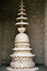 The stupa of Mohra Moradu and its votive stupa And then, between Sircap and Sirsukh is the remains of a perfectly Greek style temple, called Jandial Temple. It is a quadrangle building of 50 meters in depth, and its columns have Ionian capitals, but unfortunately the surviving parts are not many except the excavated foundations. Some have insisted that it could be a Zoroastrian temple, although it is not clear whether that is true or not. 
  Ruined Temple of Jandial
(In "UNESCO World Heritage" vol. 5. 1997, Kodan-sha )
E-mail to: kamiya@t.email.ne.jp
|