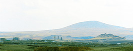
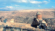
The city of Ani, whose name started to be used in the 5th century, is 1,500m above sea level and located 45km southeast of Kars, facing the Arpa Çay (Akhrian River) that forms the border between Turkey and Armenia. It now consists of urban remains of the medieval capital of Bagratid kingdom of Armenia from the 9th to 11th centuries. Before that Ani was a territory of the Kamusarakan Family until the early 8th century, and it is likely that a fortress had been constructed in the 5th century. After the conquest by the Arab army in 722, the Bagratids recovered it and Ashot III (r. 952-977) moved his capital from Bagaran to this city in 961.
Since then six kings made Ani their base, among which Ashot III especially beautified the city and tradition tells us that it had a population of 100,000 people and a thousand churches (though unlikely). Ani prospered most through the age of Gagik I (r. 990-1020), but the city was captured by the Byzantine Empire in 1045 during the age of Gagik IV, when the Bagratid dynasty was disrupted, though the Georgian Bagratid monarchy would continue until 1801.
Ani fell into the SerjuksÅf hands in 1064, and then it was ruled by the Cheddadid Muslim dynasty. During the 12th century it was often occupied by Georgians, but it recovered again in the 13th century and prospered as an Armenian city, erecting many buildings until 1236, when the Mongolian army invaded it. The city continued but suffered greatly in a large earthquake of 1318 and it was completely abandoned during the 14th century, turning gradually into ruins. Although it is said to have been 30 churches, funerary chapels, 400 houses, warehouses, 16 dovecotes, and so on, most buildings have been lost, and yet there are no other sites that retain as many remains of Armenian architecture as in Ani. In the early 20th century its excavation started under the supervision of Nikolai Marr.
It was in 1980 that I visited Ani for the first time, and in those days, one had to gain permission to visit there and moreover photography was strictly forbidden. After the collapse of the neighboring Soviet Union, restrictions have gradually been lessened. Nowadays no visiting permit is needed, and photography is possible apart from the southern part from the citadel. Since there is no public transportation from the nearest city, Kars, one hires a taxi and arranges in advance for it to come again in the evening.

MAP OF ANI (RUINS)
(From "ANI, World Architectural Heritage of
a Medieval Armenian Capital" by Peter Cowe,
2001, University of Pennsylvania)
01. Ramparts with Towers
02. A Column & Georgian church
03. The Baron's Palace
04. Surp Grigor of King Gagik
05. Surp Arakelots (Holy Apostles)
06. Surp Grigor of Abugaml Family
07. Manutche Mosque
08. The Cathedral
09. Surp Amenaprkich (Holy Savior)
10. Tigran Honents Church
__of Surp Grigor
11. Kusanats Vank (Monastery of Virgin)
12. The Citadel & a Church
13. A Church from the Peninsula
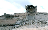
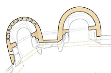
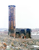
01 RAMPARTS, 989, 13c. **
 
  Plan and Cross Section of Towers
(From "Ani, Capitale de l'Arménie en l'An Mil" Raymond H. Kévorkian, 2001)
Plan and Cross Section of Towers
(From "Ani, Capitale de l'Arménie en l'An Mil" Raymond H. Kévorkian, 2001)
King Ashot III constructed during 963 to 964, to the north of the citadel, the first ramparts of Ani, at the easternmost part of which is the later Manutche Mosque. It was not long before that it was not adapted to the enlargement of the city, so his successor, Smbat II (977-990), erected a new city wall on a larger scale in the far north of the then city area in 989. It was indeed magnificent in shape accompanied with cylindrical towers, and its total length attained as long as two and half kilometers. Much later in the 13th century, under the reign of Georgia and Seljuk Dynasty, the ramparts were largely reinforced. The towers, which structurally function as buttresses, are now seriously damaged, but their inside frames are still majestic with overwhelming impact when seen from the ground.
02 A COLUMN and GEORGIAN CHURCH, 13c.
A fragment of two arches and a clustered column with an Ionic-like capital at the eastern end of the city wall is impressive, suggesting a once existing splendid arcade. It might have been too elaborate and imposing for the ornament of a military wall. To its rear, on the outskirts of the city, there remain a great number of ruins of cave dwellings on the sides of rocky hills.
The neighboring single nave church, popularly known as the ÅeGeorgian ChurchÅf due to a remaining long Georgian inscription, has almost completely collapsed except a wall with three continuous blind arches. It is written that this church was built in 1218. Since there is a tomb-like crypt, this might have been a funeral church.
03 THE BARON'S PALACE, 13c. *
As this building, the so-called BaronÅfs Palace, in the northwestern end of Ani, has no inscription, its original patron is not known. It could not have been a local lord, but more likely Tigran Honents who was the benefactor of several churches in Ani.
It stands on a sloping site facing a western gorge, so its city-side is two-storied and the rear side three. Its irregular trapezoidal plan might indicate a residence and audience room on the upper floor, and three parallel vaulted rooms, possibly used for storage, though half destroyed, on the lower.
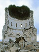
04 SURP GRIGOR of KING GAGIK, 11c. *
Surp Grigor of King Gagik, also called Gagikashen, is the largest edifice in Ani, being a round church. Like the magnificent cathedral of Zvartnots near Vagharshapat, this has a unique form of a complete four-apse church surrounded with ambulatories, enclosed with in a 36-cornered (almost a perfect circle) wall, about 10% smaller than the Zvartnots.
It is said that since the Cathedral of Zvartnots had already collapsed, Gagik I (990-1020) of the Bagratuni dynasty ordered architect Trdat to erect a round church here at Ani in the same style (1001-05). Its scale was larger than the nearby Cathedral of Ani that had also been designed by Trdat. And yet this new round church too has collapsed.
Furthermore, a church in the same style at Bana in Georgia, probably built in the 7th century, was destroyed during the Russo-Turkish Wars (1877-78), and a lesser scale church at Liakit in Azerbaijan, also in the 7th c., has now become ruins. Therefore, there exists no upper structures of this style anywhere in the world, so unfortunately, we cannot have an actual experience of such a unique space form.
  Plan of the Surp Grigor of King Gagik. Restored Elevation by Toramanyan
(From "The Armenians" Adriano Alpago Novello, 1986, Rizzoli)
Plan of the Surp Grigor of King Gagik. Restored Elevation by Toramanyan
(From "The Armenians" Adriano Alpago Novello, 1986, Rizzoli)
There might have been some flaw in this bold structural system. An epigraph discovered during the excavation of this church of Surp Grigor of King Gagik says that a weak point was found in its western part shortly after its construction, and then reinforcement work was done in 1013, but the church collapsed before long. Toramanyan presumed the cause of the collapse to be the unsuitableness of the stone that Trdat had used, but this view has not been proven.
The altar of this church was set up in the eastern apse. The circumferential walls
have three entries, on the south, west and north (also on the southeast and northwest in the case of Zvartnots) without a front porch, unlike at Zvartnots. Its circular ambulatory was two storied, lit through vertical windows for the lower story and oculi (round windows) for the upper. The largest difference from Zvartnots is the rear of the main apse not being a wall but a line of arcaded columns like other apses, in addition to the central dome being smaller.
ToramanyanÅfs excavation work in 1905-6 found a statue of Gagik I holding a model of this church in both hands. Based on this model, Toramanyan made restoration drawings of the original church, modifying the somewhat too long vertical proportion of the model.
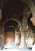
05 SURP ARAKELOTS (Holy Apostles), 10-11c, 13c. *
This is a church donated in 1031 by Abugamr, son of King Vahram of the Pahlavids. The rectangular contour embraces a four-apse worship hall and four small corner chapels. The form of this church (Surp Arakelots) is descended from the Jvari Church in Mtskheta. It takes a rare form of a central dome accompanied with four diagonal small domes like the Indian Panchayatana (five-shrined-type), the second example in Armenia next to the Katoghike (Cathedral) of Avan. Since it has unfortunately collapsed in full, we cannot see its external appearance.
 Plan of the Surp Arakelots
(From "Armenian Art" Jean-Michel Thierry, 1987, Harry N. Abrams)
Plan of the Surp Arakelots
(From "Armenian Art" Jean-Michel Thierry, 1987, Harry N. Abrams)
The extant part of the Surp Arakelots is the Gavit, or narthex, a quite ornamental building, added to the south in the 13th century. Strangely, it is not located on the west, opposite the main apse, but twisted to the south, and moreover its entrance is located on the east, with a further 90 degree bend. Visitors must turn many times to reach the main apse.
This Gavit has many diagonal arches built right across the space from each column, like latticework on a large scale, and on the central lozenge is a Muqarnas dome with an opening to allow light in. Other small parts of the ceiling partitioned by the arches are geometrically patterned in various designs with parquetry of interlaced brown and black stones.
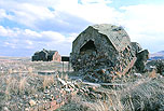
06 SURP GRIGOR of ABUGAML FAMILY, 10c. *
The church of Surp Grigor of Abugamr Family is located o the western edge of the city of Ani, facing the gorge of Tsaghkotsadzor. It is considered to have been erected at the end of the 10th century by King Grigor or his wife Shushan of the Abugamr family, a branch of the Pahlavid family. An inscription says that it was used as a funeral church for the posterity of Abugamr Pahlavid.
It is a round church with six apses, each of which has a vertical window in the wall that, along with the windows in the drum of the central dome, makes the interior bright enough. Though small, this church attracts us by its symbolic clear-cut formation. Its conical roof is still made of stone, while the stone panels on the lower roof are lost.
07 MANUTCHE MOSQUE, 10-11c, 13c. *
This mosque was originally built as a house or a palace (likely for a Catholicos), hence without a Mihrab, it was converted into a mosque during the Islamic ages and a minaret was added. Although it is said to have been constructed by Manutche, the governor-general from the Cheddadids, the actual builder is surmised to have been a century later, Abul-Maamran. Another view is that this mosque might have been remodeled from the easternmost part of the citadel ramparts of Ashot III. A plaque on the site says that this mosque was built by the Seljukids and the earliest mosque in Anatolia.
 Plan of the Manutche Mosque
(From "Documenti di Architetture Armena 12. ANI", 1984)
Plan of the Manutche Mosque
(From "Documenti di Architetture Armena 12. ANI", 1984)
Through four windows on its side wall, one can see out to the gorge of Akhrian and the landscape beyond, uncommon among world mosques. The size of the worship hall is 18.5 by 15.7 meters and its arches span five independent columns and twelve pilasters. The octagonal minaret has a decapitated top, which could have been surmounted with a conical roof or a balcony.
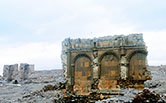
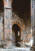
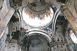
08 CATHEDRAL, 989-1001 **
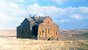
 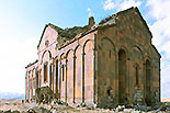
This is the cathedral of Ani designed by Trdat, the greatest architect in the history of Armenia. While European architecture was still in the stage of ÅePre-RomanesqueÅf as it is called, Armenian architecture developed to a high degree. Since it almost achieved the techniques and aesthetics of later Romanesque style, Armenian architecture is considered as one of the origins of Romanesque architecture.
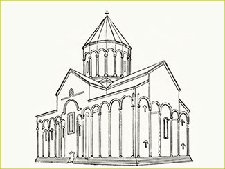
The Cathedral of Ani, Reconstruction
(From "Armenian Architectural Monuments" G. Avakian, c.1968)
Given that Trdat is known for his restoration work of the dome of Saint Sophia in Constantinople, which had collapsed in a strong earthquake, it is a great shame that the central dome and drum of this Ani Cathedral collapsed in an earthquake in the year 1319, though more than 300 years after its construction.
An inscription says that the construction on the cathedral of Ani was initiated in 989 by Smbat II of the Bagratid dynasty and was completed in 1001, 12years later, by Katranide, the queen of his successor and younger brother, Gagik I (r. 989-1020), the king of the Bagratids. While it was converted into a mosque after 1014 under the rule of Seljukids, it recovered to be a Christian church in 1124 thanks to the Georgian king David.
  __________PLAN of the Cathedral of Ani
(From "The Armenians" Adriano Alpago Novello, 1986, Rizzoli)
__________PLAN of the Cathedral of Ani
(From "The Armenians" Adriano Alpago Novello, 1986, Rizzoli)
The edifice forms a basilica with four robust pillars supporting a dome, a plan derived from the church of Surp Gayane in Vagharshapat, being the prototype three-nave and one-apse church. Although it resembles the Latin-cross plan, it lacks transepts, and its external demarcation is almost a perfect rectangle.
The shape of its roof is not plain but quite three-dimensional contrary to the simple plan, making a cross with ridges with a dome on its crossing. The dome is set on four arches bridged over four pillars, and the spandrels between arches are not squinches but pendentives. The pillars are in a clustered form with many lines, displaying a strong verticality like Gothic architecture. It is not known whether the lost roof over the central dome was conical or umbrella type.
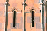
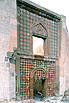
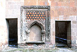
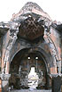
09 SURP AMENAPRKICH (Holy Savior), 11c,13c. *
The church of Surp Amenaprkich (Holy Savior) was constructed in 1036 by the prince Ablgarib of the Pahravid family in order to enshrine a fragment of the True Cross, which he brought back from Constantinople. This building is also considered to have been designed by Trdat, whose name is inscribed on the top of the south facade.
Though it suffered much during the invasion of the Seljuks after 1064, it was restored in 1193 along with the enlargement of the Gavit, which has been now lost. Its dome is said to have collapsed in an earthquake and reconstructed in 1342 by Vahram Atabek, the grandson of the prince Zakare.
  Plan & Elevation of the Surp Amenaprkich
(From "Armenian Art" Jean-Michel Thierry, 1987, Harry N. Abrams)
Plan & Elevation of the Surp Amenaprkich
(From "Armenian Art" Jean-Michel Thierry, 1987, Harry N. Abrams)
The edifice is a round church with eight apses, but curiously its external wall is not octagonal but nineteen-cornered. While the eastern apse, where the altar was installed, is made larger than the others, the southern apse was used as an entrance, in front of which might have been the Gavit. Alternate walls in the 19 successive blind arcade on the upper floor have small vertical windows, which could only have made the inside gloomy. In half domes over the apses remain fragments of murals, which, according to an inscription, were painted by Sargis Parsikian.
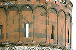
At the southern side of the church there seems to have been built a belfry that does not exist now. The church suffered large cracks on the walls in the early 20th century, and although it was repaired in 1912, its eastern half completely collapsed in 1957 (also said to have been around 1930). It is mysterious that the other half of the nearly one thousand-year-old stone building has not fallen down despite withstanding perpetual wind pressure.
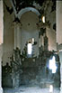
10 TIGRAN HONENTS CHURCH of SURP GRIGOR, 13c. **
 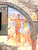
The church of Surp Grigor, standing on a cliff beside the Akhrian River at the
eastern edge of Ani, was dedicated in 1215 by an affluent citizen, Tigran Honents. This is the best-preserved building in Ani. The church is demarcated in a rectangle in plan, being hall-type with a central dome over four robust pillars contiguous to the outer walls. It is strange that each of the two inmost pillars has an opening to lead to a small oratory and an upper window, enfeebling them structurally.
It is a quite ornamental edifice, full of colorful frescoes inside, rarely seen in Armenian churches. The subjects of the murals are the Communion of Saints, the Annunciation, the Nativity, the Resurrection, the Last Supper, the deeds of Saint Grigor, and so on.
  PLAN of Tigran Honents Church of Surp Grigor
(From "Armenian Art" Jean-Michel Thierry, 1987, Harry N. Abrams)
PLAN of Tigran Honents Church of Surp Grigor
(From "Armenian Art" Jean-Michel Thierry, 1987, Harry N. Abrams)
The existence of a Gavit as an open Narthex on the west side is also uncommon, and was probably a later addition. Since its roof has collapsed, the murals, such as the Crucifixion, on the large and small tympanums over the entrance have been brought to daylight. The muralists are considered to have been Georgians, for concise descriptions were added on the murals in Georgian.
A small chapel was erected on the north of the Gavit but it has half collapsed now.
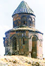
11 KUSANATS VANK (Monastery of the Virgin), 1215 *
A small church on the top of a cliff facing the Akhrian River is called the Kusanats Vank (Monastery of the Virgin). An inscription says that it was also built by Tigran Honents. As its details are similar to those of the foregoing Tigran Honents Church of Surp Grigor, it is considered that the same architect designed both.
The church is a six-petalled round one, surmounted with an umbrella-type stone roof. Its twelve-sided upper story looks like a mini-sized Haricha Vank (1201). The reason its porch, now lost, was erected not on its easily accessible side but on the unsafe cliff side is to position it on the west, which is the opposite side of the apse. Furthermore, a smaller chapel was independently erected beside the porch on its cliff-side. On its hill side are scattered debris of buildings for the monastic life.
12 CITADEL & CHURCH, 10-11c.
Although the citadel on a hill is ruined now, it had a palace at its highest point with a gate on the west, from which a street stretched 90 meters, dividing the palace north and south. The two-storied building was for residence and its upper floor seems to have been a grand hall. The palace also had a Roman bath.
The royal chapel was in the eastern front of the extensive courtyard, with a single nave surmounted with a vault over pilasters. Those pilasters have fluting, and their tops sustain arches carved in floral or geometric patterns. Despite the year of its construction being unrecorded, it is said to have been erected around the 10th century. Although there are also some remains of four-apse or six-apse chapels, further research was restricted.
 Plan of the Citadel and Church
(From "Ani, Capitale de l'Arménie en l'An Mil"
Raymond H. Kévorkian, 2001, Paris Musées)
Plan of the Citadel and Church
(From "Ani, Capitale de l'Arménie en l'An Mil"
Raymond H. Kévorkian, 2001, Paris Musées)
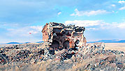
13 A CHURCH from the PENINSULA, 13c.
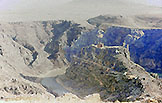
On the narrow peninsula protruding to the U-shaped bend in the Akhrian River at the southernmost part of Ani was once a small fort commonly called Kiz Kale in Turkish, meaning the VirginÅfs Fort. It is prohibited to approach the small church in this fort, so I had to be satisfied taking a photograph from a great distance.
It is a single-nave church, sand it is not known whether it had a dome or not.
|

