|
RED FORT ( LAL QILA ) in
|
|
RED FORT ( LAL QILA ) in
|
|
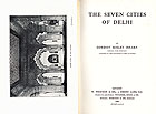
Even if Delhi has not necessarily been the capital of India continuously, it has a quite long history. During its Islamic period after the 13th century, seven cities successively occurred in slightly shifting locations in the Delhi area, based on which Gordon Risley Hearn wrote a book entitled ÅgThe Seven Cities of DelhiÅh in 1906. The phrase ÅeSeven Cities of DelhiÅf broadly circulated, though the British king George V declared, five years after its publication, that a new capital of the British Indian Empire would be constructed, transferred from Calcutta. This is the eighth city, referred to as New Delhi, completed in 1931. As a result, since then, the seventh city, Shahjahanabad, the capital of the Mughal Dynasty, including the Lal Qila (Red Fort), has been called Old Delhi.
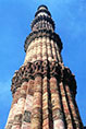
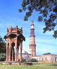
However, when Gordon Hearn wrote that book, the word ÅfOld DelhiÅf indicted the zone around the first city, Lalkot, where the Qutub Minar inscribed on the UNESCO World Heritage List is located. Even the 14th edition of John MurrayÅfs "Handbook for Travellers in India Burma and Ceylon", publishd in 1933, still referred to the Qutub district as ÅeOld DelhiÅf. Since there is a distance of 15km in a straight line between the Qutub Mosque and the Delhi fort, the two could be considered as discrete cities in the medieval and early modern ages. When simply saying ÅeDelhiÅf before the independence of India in 1947, it indicated Shahjahanabad, its northern area of Civil Line (Civil Station), and the further northern old cantonment (British armyÅfs living area), which was the stage of the Indian Mutiny. Shahjahanabad was called ÅeNew DelhiÅf until the early 1900s. In advance of expatiation of the Delhi Fort constructed by Shah Jahan, let us take a glance at the successive older cities of Delhi in historical order.
The name Delhi was derived from the city ÅeDilliÅf established by the king of Kanauj, Delu, in the first century B.C. Its location is supposed to have been between Qutub and Tughlaqabad, which will be mentioned later. Even though it was described by Ptolemy, a mathematician and geographer in ancient Alexandria, as ÅeDaidalaÅf, nothing of its remains have been found. According to tradition there was a city named ÅeIndraprasthaÅf prior to Dilli around Purana Qila to be mentioned later. It was described in the ÅgMahabarataÅh as the city whose site was chosen by the prince Yudhishthira, the oldest of the five Pandava brothers. Through this national epic that all Indians know, the name Indraprastha is also very popular, but there is no evidence of its actual existence in the past.
Though Dilli remained as a small city for ages, the Tomar tribe of Rajput occupied the city in the eighth century and developed it as their capital. And then in the 11th century the king Anangpal surrounded the city with ramparts, a part of which still survives, renaming it ÅeLalkotÅf. 
The city of Delhi entered upon a new era when the army of Muhammad of Ghori assaulted and defeated Rajputs in 1192 and conquered the Delhi area. The commander Qutub al-Din Aibak was entrusted the rule of Delhi as Muhammad returned to Afghanistan, and when the monarch was assassinated he became independent and established his own Slave Dynasty (1206-90), making ÅeQila Rai PithoraÅf his capital city.
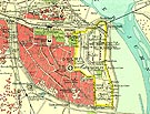
While changes of Islamic dynasties occurred four times thereafter, every king took the title of Sultan and kept Delhi as his capital, so Islamic dynasties in Northern India for 320 years through the middle ages are called the ÅeDelhi SultanateÅf as a whole. The second, Hirji Dynasty (1290-1320) constructed a new capital ÅeSiriÅf (2) at a little distance to the northeast and also surrounded it with ramparts. The two citiesm about 4km distant from each other, seems to have both prospered. The third dynasty, the Tughlaq (1320-1413), was more enthusiastic about building activity. The first sultan, Ghiyas al-Din Tughlaq, constructed the third city of Delhi, ÅfTughlaqabadÅf (3), much more to the east. (After that, new cities were often designated after the constructorÅfs name with the suffix Åf-abadÅf, meaning city.) As the site of Tughlaqabad was set on a table mountain, it would not have been possible to obtain enough water apart from rainwater, due to which the city was abandoned unfinished. Only the excellent mausoleum of Giyas al-Din is left in a small fortified enclosure projecting from the large city boundary.   The city map and walls of Tughlaqabad
His son, Muhammad Shah (r. 1325-1351), returned to the older area of Delhi. As Lalkot (1) and Siri (2) then existed too far apart from each other, hindering efficient rule, he constructed the fourth city, ÅeJahanpanahÅf (4), to connect them into one. The name means Åethe protector of the worldÅf. Muhammad commenced the construction in 1325 and encircled this vast city with stone ramparts. However, the third Sultan of the Tughlaq Dynasty, Firoz Shah, made a new city, ÅeFirozabadÅf (5), to the far north. Although what survives now is only its citadel, Firoz Shah Kotla, its urban area would have been much more enormous, spreading to later Shahjahanabad and New Delhi.
The fourth dynasty, the Sayyd (1414-51), was too feeble to be able to build a new city, likewise the last dynasty, the Lodi (1451-1526). The sixth city of Delhi was established by the second emperor of the Mughal Dynasty (1526-1858), which had defeated the Lodi Dynasty and would grow into an unrivaled empire afterward in the early modern age.

Nevertheless, Humayun was defeated by Sher Shah, the Sultan of the Sur Dynasty that countered the Mughals, and was obliged to escape to Persia. After 15 years staying in Persia, Humayun returned home to India and overthrew the Sur Dynasty with the aid of the Persian army. He rebuilt the Mughal Dynasty and came back to the Purana Qila, but the next year he fell down the stairs of his library and all too quickly died. His tomb is the ÅeMausoleum of Humayun in DelhiÅf, one of the UNESCO World Heritage sites in India.
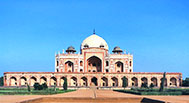
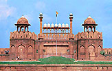
On the other hand, Sher Shah of the Sur Dynasty had been a quite competent sovereign, though in a short life. After taking the city of Dinpanah, which was being constructed by Humayun, Sher Shah established in 1540 a new fortified city of ÅeShergarhÅf, which included Dinpanah and Purana Qila. The third and fourth Mughal emperors, Akbar and Jahangir, resided in Agra (Akbarabad), Lahore (now in Pakistan), and a new capital of Fatehpur Sikri rather than in Delhi, during which Delhi became less flourishing. And yet the fifth emperor, Shah Jahan (1592-1666), led Delhi again to its prosperity, constructing a new city of Shahjahanabad (7), designated after his name, in the northernmost part of the Delhi area and made it the capital of his empire.
( THE CITY of SHAH JAHAN, now OLD DELHI )
While Shah Jahan is mainly known for the erection of a mausoleum for his beloved wife, the Taj Mahal, he also built a number of monuments in Delhi and Agra so that he was described as the greatest king in terms of construction in the history of India.
Delhi is a rare example of a multilayered city in world history, in which many cities existed slightly shifting their locations through time. Usually an old city develops by enlargements and modifications, as in Rome, Paris, Istanbul, and Beijing. Only Cairo resembles Delhi in its multilayered character; in the 7th century the Islamic army conquered the fortress town of Babylon, originally established by the Roman Emperor Trajan in the 1st century on the location of the southernmost part of current Cairo, and constructed next to it a new garrison town called al-Fustat. In the 9th century the city of al-Qatai was founded north of it, and then in the 10th century the city of al-Qahira (the Victorious) further north, from which the English name Cairo would stem.

The distances among multilayered cities in Delhi are much larger than in Cairo. Such a peculiar development was, on the one hand, the result of each dynastyÅfs or SultanÅfs desire for the display of power; on the other hand it is supposed that there was another reason in case of Delhi: alterations in the flowing course of theYamuna River. Facing a river or a sea is convenient for a city to make use of transportation by water both in commerce and for military acts. The ancient city of Lalkot in the Hindu age is supposed to have faced the Yamuna too. It can be said that in the wake of the migration of the course of the Yamuna to the east, the city also had to be successively relocated, although it would have left sandy land between city wall and the river, due to the reduction of the river width during the dry season. When Shah Jahan constructed the seventh city of Delhi, he also made its eastern wall face the Yamuna for the cityÅfs military defence as well as taking advantage of the transportation of building materials, such as stones, bricks and cement, by the river. Later the river course moved further to the east, leaving a narrow flat land between the city and the river that has been used for the sites of the memorials of Gandhi or Nehru family since the Independence of India.
The decisive factor for choosing the site of Shahjahanabad was the existence of a small fort named Salimgarh that had been constructed in 1546 by Salim Shah, son of Sher Shah of the Sur Dynasty. It was built in a protruding form into the Yamuna River as a strategic military point to control the transportation through the river.

As referred in the previous section, the second Mughal emperor, Humayun, was defeated by the Sur Dynasty in 1540 and obliged to escape to Persia, at the court of which he would stay for 15 years under the protection of the Safavid emperor, Tahmasb I (r. 1524-76). In contrast, the succeeding third emperor, Akbar, was not so wholeheartedly enamored by Persia but intended to unite Islam with Indian traditional culture. However, the fourth, Shah Jahan, reverted to Persian world. This is most prominent in the Taj Mahal and also noticeable in his town planning of Shahjahanabad and the palace designs in its fort. It was Shah Abbas the Great (r. 1587-1629) who gave the Safavid Empire the grandest power and prosperity in its history. His new capital, Isfahan, which he constructed and transferred from Qazvin in 1597, was so beautiful as to be referred to as Åehalf of the worldÅf. It is supposed that Shah Jahan took Isfahan as a model in various aspects in designing his new capital city of Shahjahanabad from 1639. Chandni Chowk Avenue (37m in width and 1,390m in length) in Shahjahanabad imitated Chahar Bagh Avenue (48m in width and 1,870m in length) in Isafahan. Shah Jahan intended to create a verdurous city in arranging many charbaghs (four quartered gardens) around the avenue as around IsfahanÅfs Chahar Bagh Avenue. The word ÅeChandni ChowkÅf means ÅeMoonlight SquareÅf. The avenue originally had an octagonal square, from which the avenueÅfs name derived, made by Jahan Ara, a darling daughter of Shah Jahan. Although Shah Jahan did not made such a huge square as the Royal Square of Isfahan, the courtyard of the Jami Masjid (Friday Mosque) of Delhi on high ground is appropriate to be called a grand square rather than a courtyard. It is as alrage as two thirds of the San Marco Plaza in Venice, allowing people from here to command an overall view of the city, Delhi fort, and even the Yamuna River. And another square is the formal one inside the fort, measuring one third of the Royal Square of Isfahan.
The population of Shahjahanabad reached 300,000 in the 17th century, while Isfahan had a population of 700,000. Being on lesser scale, the layout of Shahjahanabad is simpler and more comprehensible. The whole city, of a half-fan-like shape, was encircled with city walls, which were built between 1651 and 1658, and in its north end, along the Yamuna River, was constructed a citadel, where Shah Jahan moved in from Agra fort in 1648.

The citadel is not a simple stronghold but a Åecity within a cityÅf that embraces not only military facilities and a monarchÅfs court but also an inner town, which has a Bazar (market) for ornamental goods like jewelry, clothing, furniture and carpets to supply to the court, and so on, and a residential quarter for inhabitants who supported the court and the military. Its population was 60,000 to 100,000. It is said that the architects of the Delhi Fort were Ustad (Master) Ahmad Lahori and Ustad (Master) Hamid, the former was also the designer of the Taj Mahal. Despite the design process not being clear, by looking at the plan of the fort, we can see it was planned on the basis of complete geometrical rationality with an overall right angle order, as if designed on a drafting board by a modern architect.
First of all the fort was faced onto the Yamuna River along its eastern side, accompanied by Salimgarh, the military stronghold, to the north. The fort itself was surrounded with solid red sandstone walls on its west and south sides, and consisted of the inner town of the western one third, and the Court of the eastern two thirds on the river side.

On the other hand the inside of the citadel was fully exposed to view from this square and so it would be easy for enemies to invade the citadel from here. Due to this apprehension the sixth Mughal emperor, Aurangzeb, constructed a barbican around the Lahore Gate to protect the fort, making the approach from the outer city full of turns, namely convenient to defend from an enemy. However, it reduced the importance of the outer square, breaking down Shah JahanÅfs original concept.
The southern gateway of the fort was the Delhi Gate, from which one headed to the then Old Delhi, Jahan Panah, and another imperial city, Agra, through another Delhi Gate, a city gate. Since Agra was called Akbarabad as AkbarÅfs city in those days, both the city gate and the gateway of the fort were referred to as the Akbarabad Gate. As seen in the above plan, the nuclei of the town planning of the Red Fort are crossed axes of A-A, which extends from the Lahore Gate to the east, and B-B, from the Delhi Gate to the north. On a grid based on those axes of coordinates are arranged all facilities in the fort, so it can be identified with the principle of the Charbagh (quadripartite garden), dividing the overall fort into four quarters. In the fort were many gardens, all of which were made as Charbaghs, applying the entire citadel to a geometric composition based on the grid system.
On the A-A axis appears first of all a covered Bazaar, rarely seen in India, called Chatta Chowk, , and then on the point of intersection with the B-B axis is a grand central square with a central pond. Nowadays Chatta Chowk still flourishes with souvenir shops for tourists. At the end of the central square on the A-A axis is the Naqqar Khana or Naubat Khana (Music Pavilion), in the upper story of which a band would beat drums five certain times a day and announce with instruments the arrivals of nobles and visitors. It is said that they played music all day on holidays. People, except members of the royal family, got out of horses or vehicles here and went into the court area on foot. Passing through the lower story of the Naqqar Khana, one entered a space, as large as the central square, surrounded with colonnades, namely the forecourt of the Diwan-i-Am (Public Audience Hall).
 
The Diwan-i-Am is a great open hypostyle hall with 30 pairs of red sandstone pillars, at the innermost place of which is an imperial throne where Shah Jahan would attend every day to receive people in audience, accepting petitions and conducting trials. Beyond the Diwan-i-Am was the area of the royal court where the common people could not enter, with a line of palace buildings arranged along the Yamuna River. The rear of the Diwan-i-Am was the Rang Mahal (Pleasure Palace), from which, lined up to the north, was the Khwabgah (EmperorÅfs Sleeping Chamber), Diwan-i-Khas (Private Audience Hall), Hammam (Bath House), and Moti Mahal (a garden pavilion of the Hayat Bakhsh Garden), and furthest to the north was the Shah Burj Pavilion. Through those buildings flowed water in a waterway in a straight line, with exquisitely carved water basins of white marble on the way.
Though one can feel it might have been insecure as all the buildings from administrative ones to the seraglio faced outwards, there was no danger of attack because the premises were close to 20 m high over the river.   The Diwan-i-Khas and Moti Masjid The most refined palace was the Diwan-i-Khas (Private Audience Hall) with dimensions of 20 by 20m, where only high ranking courtiers were able to be received in audience by the emperor. It was entirely finished with white marble, with a Chhatri on each corner of the roof. Particularly resplendent in formation was the Moti Masjid (Pearl Mosque), a royal oratory, surmounted with three bulbous domes of white marble. It was constructed by the emperor Aurangzeb and can be referred to as a genuine Baroque piece of Indian architecture. There is also a white marble mosque of the same name, the Moti Masjid, in Agra Fort. It is much larger than the one in Delhi Fort, and was the Jami Masjid (Friday Mosque) of Agra, admitting entrance to the common people, until the Jami Masjid in the outer city was completed. In Delhi, probably because the Jami Masjid was planned to be built in the outer city from the first, there was no large mosque in the fort.
  Charbaghs and a garden pavilion in the Fort
Many large and small Charbaghs (quadripartite gardens) were laid out in the court area and their flourishing trees and garden pavilions made comfortable places of recreation. Shah Jahan wished to materialize on earth the heavenly paradise that is described in the ÅgKoranÅh promised to pious Muslims. It is written on the northern and southern walls of the Diwan-i-Khas:
|
